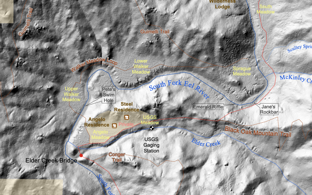
- Reserve Map trails, creeks, pools, facilities, topography
- Digital Elevation Models & GIS Coverages
- Google Map and Driving Directions
- Map of the Angelo Coast Range Reserve boundaries, facilities, private areas, vegetation map coming soon!
The following maps cover all or part of the reserve and nearby areas (direct download available when maps are in the public domain)
Geology
| Scale | Year | Map/Authors | Link |
| 1:62,500 | 1956 | Geologic Map of the Laytonville Valley Area, Mendocino County, California, Showing Location of Wells, United States Department of the Interior, Geological Survey | USGS – 1956 – Laytonville.pdf |
| 1:100,000 | 1989 | Reconnaissance geologic map of the Covelo 30- by 60-minute Quadrangle, Northern California (No. MF – 2001). United States Geological Survey. Jayko, A.S., Blake, M.C., McLaughlin, R.J., Ohlin, H.N., Ellen, S.D., Kelsey, H.M. | Jayko et al – 1989 – Covelo.pdf |
| 1:250,000 | 1960 | Geologic map of California : Ukiah sheet. Jennings, C.W., Strand, R.G | Jennings and Strand – 1960 – Ukiah.pdf |
| 1:250,000 | 2012 | Aeromagnetic and Aeromagnetic-based Geologic Maps of the Coastal Belt, Franciscan Complex, Northern California, V.E. Langenheim, R.C. Jachens, C.M. Wentworth, and R.J. McLaughlin | Langenheimet al – 2012 – sheet1.pdf Langenheim et al – 2012 – sheet2.pdf Langenheim et al – 2012 – sheet3.pdf Langenheim et al – 2012 – pamphlet.pdf |
| 1:>1,000,000
(Figure 3) |
1960 | Geologic reconnaissance of the northern Coast Ranges and Klamath Mountains, California, with a summary of the mineral resources. Irwin, W.P. California Division of Mines | Irwin 1960 Geologic Recon.pdf |
| 1:>1,000,000
(Figure 2) |
2013 | Previously unrecognized regional structure of the Coastal Belt of the Franciscan Complex, northern California, revealed by magnetic data. Geosphere 9, 1514–1529. Langenheim, V.E., Jachens, R.C., Wentworth, C.M., McLaughlin, R.J. doi:10.1130/GES00942.1 | Copyrighted material |
USGS Topography
| Scale | Year | Map | Contact us for PDFs |
| 1:24,000 | 1967/1994 | Cahto Peak (includes eastern portion of Elder Creek) | CA_Cahto_Peak_288743_1967_24000_geo.pdf (12.3 Mb) |
| 1:24,000 | 2012 | Cahto Peak (vector contour and geographic features; raster orthoimagery) | CA_Cahto_Peak_20120224_TM_geo.pdf (22.2 Mb) |
| 1:24,000 | 2015 | Cahto Peak (vector contour and geographic features; raster orthoimagery) | CA_Cahto_Peak_20150303_TM_geo.pdf (21.6 Mb) |
| 1:24,000 | 1966 | Lincoln Ridge (includes western portion of Elder Creek) | CA_Lincoln Ridge_292322_1966_24000_geo.pdf (17.3 Mb) |
| 1:24,000 | 2012 | Lincoln Ridge (vector contour and geographic features; raster orthoimagery) | CA_Lincoln_Ridge_20120224_TM_geo.pdf (30.5 Mb) |
| 1:24,000 | 2015 | Lincoln Ridge (vector contour and geographic features; raster orthoimagery) | CA_Lincoln_Ridge_20150303_TM_geo.pdf (21.3 Mb) |
| 1:100,000 | 1981 | Covelo | CA_Covelo_299067_1981_100000_geo.pdf (37.0 Mb) |
| 1:250,000 | 1960 | Ukiah | CA_Ukiah_302178_1960_250000_geo.pdf (22.9 Mb) |