National Science Foundation award #1331940.
Surprisingly, we need to look inside hillslopes to understand variations in atmospheric moisture, the magnitude and chemistry of river flows, the dynamics of ecosystems, and, even coastal ocean productivity. These connections arise in a deep, unexplored landscape of weathered bedrock, populated by microbes, that lies beneath the hillslope surface and below the soil mantle and above a fresh bedrock boundary. Rain and snow melt can penetrate this weathered bedrock, be held as rock moisture and be exploited by trees, which return this moisture to the atmosphere through release (transpiration) from leaves.
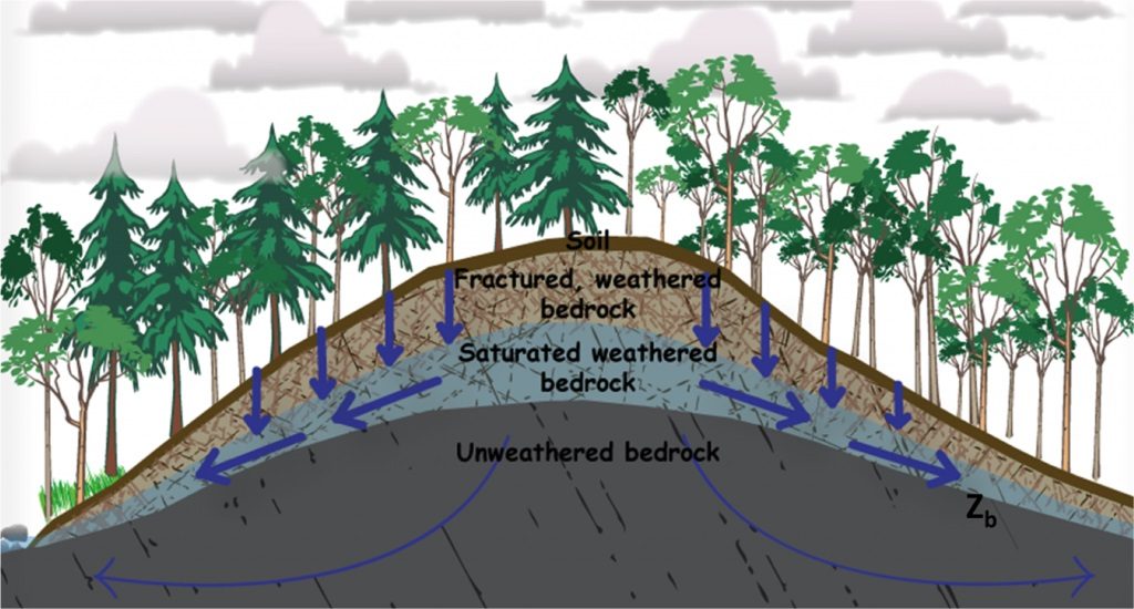
The Eel River Critical Zone Observatory: exploring how the critical zone will mediate watershed currencies and ecosystem response in a changing environmentBedrock properties influence how much moisture is available to plants, so in turn may determine which species can persist, especially in seasonally dry environments. The water released by trees influences air humidity and temperature, and the tree type affects how much solar energy is reflected or absorbed. Collectively these feedbacks influence atmospheric energy and circulation (and momentum). Rain and snow melt also penetrate to the underlying fresh bedrock boundary where water perches and flows as groundwater to streams through the weathered bedrock. This can control the timing, magnitude, and chemistry of runoff to rivers, especially during summer low flow periods. Hence, river ecosystems and the coastal oceans (where rivers discharge) are recipients of water and nutrients derived from deep inside hillslopes. The entire zone from vegetation canopy down through the soil and weathered bedrock to the start of fresh bedrock is referred to as the “critical zone.” This zone mediates these “watershed currencies”– water, sediment, solutes (dissolved elements in water), gases, organisms, energy and momentum–that are exchanged and transformed in the course of biological and physical interactions across landscapes. In October 2013, nine Berkeley faculty from 3 colleges and 4 departments established the Eel River Critical Zone Observatory (ERCZO) in Northern California for intensive field investigations of key mechanisms controlling these currencies and their consequences for water resources and ecosystem sustainability.
 ERCZO “tasks” address four questions:
- Do plants in seasonally dry environments rely on moisture from the weathered bedrock beneath the soil and if so how might bedrock properties then affect this availability and thus the resilience of vegetation to climate change?
- As moisture conditions change, how do microbes in the critical zone influence the water chemistry and gasses discharged from hillslopes?
- What controls the spatial extent of channels that remain wet (standing or flowing water) in the network of channels draining seasonally dry environments? and
- Will changes in critical zone currencies, induced by climate or land use change, lead to sudden shifts in river and coastal ecosystems?
Motivated by anticipated increase in climate extremes (especially extended drought) and accelerating societal demand for water, we focus on filling knowledge gaps that not only inhibit our ability to forecast the magnitude of future change of systems, but even the sign of that change. The ERCZO is locally rooted in the Angelo Coast Range Reserve in the upper South Fork of the Eel River, but extends to larger watershed and regional scales. It is dedicated to detecting, explaining, and predicting driving mechanisms that connect river flow, forest and river biology, and other watershed currencies to processes that operate in the critical zone. ERCZO scientists are building towards a capstone model, AWESOM, (Atmosphere-Watershed-Ecosystem-Stream-Ocean Model). Firmly rooted in strong, quantitative empiricisms and mechanistic descriptions of how the system works, AWESOM will be used to ask “what if” questions about possible future climate and land use scenarios, and the consequences at local to regional scales for runoff regimes and ecosystem conditions.
The official NSF CZO program funding ended in December 2020. You can view the archived ERCZO website here.
View our current list of ERCZO publications here.
Recently, ERCZO PI’s and staff have received additional funding from the NSF Hydrologic Sciences and GEO programs, the CA Bureau of Cannabis Control, and the CDFW Prop 68 program to support our ongoing research efforts and our data curation system, Dendra. Click the links below for more details on our currently funded projects.
Cannabis Water-Use Impacts to Streamflow and Temperature in Salmon-Bearing Streams (BCC)